News
Artificial signals in GPS, GLONASS and Galileo series explained by the UPWr scientists!
14-02-2022
Global Navigation Satellite Systems (GNSS) are widely used for the monitoring of phenomena occurring on the planet Earth. For this purpose, we usually use observations of changes in the position of ground receivers, determined by observations of navigation satellites. The American GNSS system, called Global Positioning System (GPS), plays a key role and is continuously used most often by users.
Errors in GNSS positioning
However, the observed temporal changes in the coordinates of ground stations obtained using GPS observations are the resultant of real natural phenomena, anthropogenic processes, and systematic errors of the GPS system. This raises the question of how to separate the errors of the GPS technique from the changes we actually want to observe, such as station displacements caused by ocean tides?
The last decade has seen dynamic changes in the satellite navigation sector with the development of European Galileo, Russian GLONASS and Chinese BeiDou. These systems differ in satellite design, signal frequencies and orbit parameters. The multiplicity of navigation systems allowed us to evaluate the incompatibilities resulting from the use of different constellations and highlighted the consequences of using individual GNSS systems, and combining observations from different systems in the so-called multi-GNSS solutions.
Reasons for differences between GPS, GLONASS and Galileo lie in the orbits
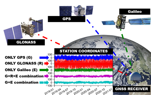
In a paper recently published in the Journal of Geophysical Research: Solid Earth, IGG researchers outlined the differences in GNSS station coordinates determined using GPS, GLONASS and Galileo. It was shown that each system introduces significant changes to the measured coordinates, with the magnitude of up to the level of several centimeters. The researchers first described and characterized in detail a special group of signals specific to each GNSS system, and called it the orbital artifact group. The presence of so-called orbital artifacts was demonstrated by analyzing a 2-year series of coordinates of fifteen globally distributed stations and tropospheric delay parameters using the Precise Point Positioning (PPP) absolute positioning technique.
GPS generates errors regularly recurring every 12h
The most dominant orbital artifacts for Galileo appear with periods of 14.08 h, 17.09 h, 34.20 h, 2.49 d, ∼ 3.4 d. Analogous signals for GLONASS appear with periods of 5.63 h, 7.36 h, 10.64 h, 21. 26 h, 3.99 d, and ∼8 d. GPS orbital signals appear in station coordinates with periods corresponding to the satellite circulation period, which coincides with the harmonics of the solar tide K1 (23.93h) causing inconsistencies between GPS-based analyses and ocean tide geophysical models reaching an average of 12 mm for the tide K2 (12.97h) in the elevation component of station coordinates.
As noted, many of the signals presented appear with periods of several hours. As a result, generating daily solutions from high-frequency (5 minutes) GNSS data leads to signal distortion resulting from failure to satisfy the sampling theorem. The distortion manifests itself in incorrect interpretation of long-period signals (so-called aliasing) e.g. half-yearly and annual signals.
Galileo has fewer errors than GPS and GLONASS
Galileo is less susceptible to orbital signals than GPS or GLONASS. This difference is mainly visible for the eastern coordinate. The determination of daily coordinate changes based on Galileo alone is up to 55% and 36% better than from GLONASS and GPS, respectively.
In addition, the amplitude of the orbital signals varies for different station locations and depends on the geometry of the GNSS observations and the dominant direction of satellite overflights. For example, due to the large inclination of the GLONASS satellite orbital planes (~65°), stations located in low latitudes observe mainly north-south satellite overflights, making the estimated eastern component of coordinates from GLONASS more susceptible to orbital artifacts than GPS and Galileo.
Best combination - Galileo+GPS
Finally, using a combination of GPS and Galileo increases the precision of station coordinates by 10% compared to the best solution based on Galileo alone. The GPS+GLONASS+Galileo solution yields a similar magnitude of improvement as the GPS+Galileo combination, so adding Galileo alone has a greater impact than the possible impact of GLONASS. However, a significant advantage of GLONASS, compared to GPS and Galileo, is its orbit inclination, which is about ten degrees greater than that of the other two systems. This feature is essential in high-latitude regions, where GLONASS signals can be tracked for much longer periods of time and at higher angles above the horizon. The user should select the set of GNSS constellations according to the needs.
Please find more details in the orginal paper:
Zajdel, R., Kaźmierski, K., & Sośnica, K. (2022). Orbital artifacts in multi-GNSS Precise Point Positioning time series. Journal of Geophysical Research: Solid Earth, 127, e2021JB022994. https://doi.org/10.1029/2021JB022994
This work is funded by National Science Center (NCN) grant UMO-2019/35/B/ST10/00515. R. Zajdel is supported by the Foundation for Polish Science via the START stipend program and NCN grant UMO-2020/36/T/ST10/00097. The APC/BPC is cofinanced by Wroclaw University of Environmental and Life Sciences.
Errors in GNSS positioning
However, the observed temporal changes in the coordinates of ground stations obtained using GPS observations are the resultant of real natural phenomena, anthropogenic processes, and systematic errors of the GPS system. This raises the question of how to separate the errors of the GPS technique from the changes we actually want to observe, such as station displacements caused by ocean tides?
The last decade has seen dynamic changes in the satellite navigation sector with the development of European Galileo, Russian GLONASS and Chinese BeiDou. These systems differ in satellite design, signal frequencies and orbit parameters. The multiplicity of navigation systems allowed us to evaluate the incompatibilities resulting from the use of different constellations and highlighted the consequences of using individual GNSS systems, and combining observations from different systems in the so-called multi-GNSS solutions.
Reasons for differences between GPS, GLONASS and Galileo lie in the orbits
In a paper recently published in the Journal of Geophysical Research: Solid Earth, IGG researchers outlined the differences in GNSS station coordinates determined using GPS, GLONASS and Galileo. It was shown that each system introduces significant changes to the measured coordinates, with the magnitude of up to the level of several centimeters. The researchers first described and characterized in detail a special group of signals specific to each GNSS system, and called it the orbital artifact group. The presence of so-called orbital artifacts was demonstrated by analyzing a 2-year series of coordinates of fifteen globally distributed stations and tropospheric delay parameters using the Precise Point Positioning (PPP) absolute positioning technique.
GPS generates errors regularly recurring every 12h
The most dominant orbital artifacts for Galileo appear with periods of 14.08 h, 17.09 h, 34.20 h, 2.49 d, ∼ 3.4 d. Analogous signals for GLONASS appear with periods of 5.63 h, 7.36 h, 10.64 h, 21. 26 h, 3.99 d, and ∼8 d. GPS orbital signals appear in station coordinates with periods corresponding to the satellite circulation period, which coincides with the harmonics of the solar tide K1 (23.93h) causing inconsistencies between GPS-based analyses and ocean tide geophysical models reaching an average of 12 mm for the tide K2 (12.97h) in the elevation component of station coordinates.
As noted, many of the signals presented appear with periods of several hours. As a result, generating daily solutions from high-frequency (5 minutes) GNSS data leads to signal distortion resulting from failure to satisfy the sampling theorem. The distortion manifests itself in incorrect interpretation of long-period signals (so-called aliasing) e.g. half-yearly and annual signals.
Galileo has fewer errors than GPS and GLONASS
Galileo is less susceptible to orbital signals than GPS or GLONASS. This difference is mainly visible for the eastern coordinate. The determination of daily coordinate changes based on Galileo alone is up to 55% and 36% better than from GLONASS and GPS, respectively.
In addition, the amplitude of the orbital signals varies for different station locations and depends on the geometry of the GNSS observations and the dominant direction of satellite overflights. For example, due to the large inclination of the GLONASS satellite orbital planes (~65°), stations located in low latitudes observe mainly north-south satellite overflights, making the estimated eastern component of coordinates from GLONASS more susceptible to orbital artifacts than GPS and Galileo.
Best combination - Galileo+GPS
Finally, using a combination of GPS and Galileo increases the precision of station coordinates by 10% compared to the best solution based on Galileo alone. The GPS+GLONASS+Galileo solution yields a similar magnitude of improvement as the GPS+Galileo combination, so adding Galileo alone has a greater impact than the possible impact of GLONASS. However, a significant advantage of GLONASS, compared to GPS and Galileo, is its orbit inclination, which is about ten degrees greater than that of the other two systems. This feature is essential in high-latitude regions, where GLONASS signals can be tracked for much longer periods of time and at higher angles above the horizon. The user should select the set of GNSS constellations according to the needs.
Please find more details in the orginal paper:
Zajdel, R., Kaźmierski, K., & Sośnica, K. (2022). Orbital artifacts in multi-GNSS Precise Point Positioning time series. Journal of Geophysical Research: Solid Earth, 127, e2021JB022994. https://doi.org/10.1029/2021JB022994
This work is funded by National Science Center (NCN) grant UMO-2019/35/B/ST10/00515. R. Zajdel is supported by the Foundation for Polish Science via the START stipend program and NCN grant UMO-2020/36/T/ST10/00097. The APC/BPC is cofinanced by Wroclaw University of Environmental and Life Sciences.
 back
back |
 |
 |
 |
Contact
|
INSTITUTE OF GEODESY AND GEOINFORMATICS
Wroclaw University of Environmental and Life Sciences Grunwaldzka 53 50-357 Wroclaw NIP: 896-000-53-54, REGON: 00000 18 67 Phone +48 71 3205617 Fax +48 71 3205617 e-mail: igig@upwr.edu.pl |