News
GNSS tomography-based monitoring of hailstorm events
04-02-2026
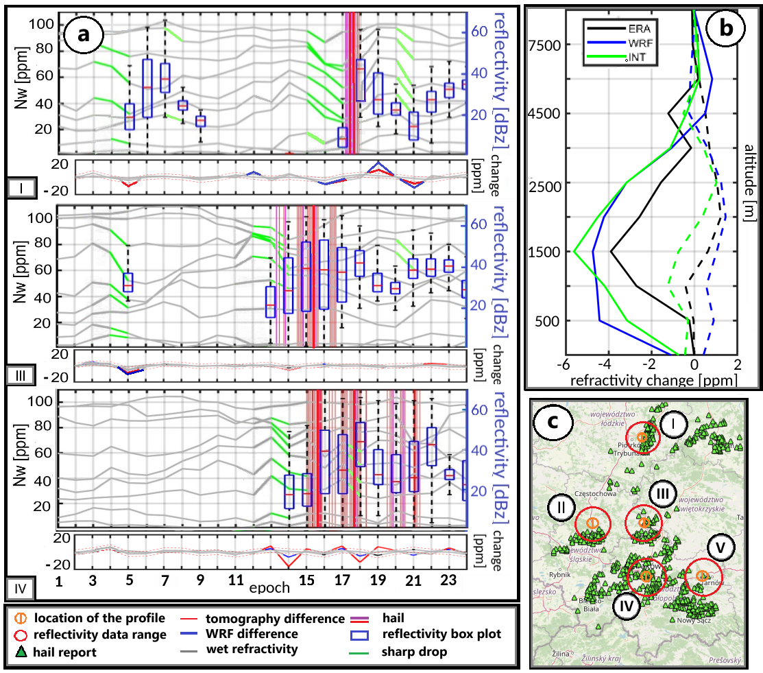
Monitoring convective phenomena, such as heavy rainfall and hailstorms, is crucial for improving our understanding of processes occurring in the troposphere and for enhancing short-term weather forecasts. Traditional observational techniques, including radiosondes, often lack sufficient temporal and spatial resolution to effectively capture the rapid and localized changes that precede severe storms. One response to these limitations is the application of integrated GNSS tomography, which combines ground-based GNSS observations with radio occultation (RO) data.
In the presented article, three hailstorms that occurred over southern Poland in 2021 and 2022 were analyzed. The results show that the tomography model recorded a clear and systematic decrease in wet refractivity values in the onset of the analyzed events, averaging approximately 8-10 ppm. This phenomenon is interpreted as a signature of water vapour condensation and the intensification of updrafts, which are key processes in the development of supercell thunderstorms.
The integration of GNSS and RO data within a single tomographic model significantly improved agreement with radiosonde observations, reducing the RMS error by up to 50% compared to the a priori ERA5 model fields. Importantly, GNSS tomography proved to be more sensitive to pre-hailstorm signals than the WRF model, enabling the identification of vertical convective “columns” characterized by very large refractivity gradients.
The obtained results confirm that integrated GNSS tomography is a promising tool for detecting early signals of severe storms and hail, particularly in the context of observing atmospheric processes occurring several hours before the onset of extreme weather events. This method may in the future become an important complement to weather monitoring systems and support the development of a new generation of early warning systems.
A. Cegła, M. Taszarek, M. Kryza, W. Rohm and G. Moeller, "Detecting Signatures of Giant Hail Events with Integrated GNSS tomography: A case study over southern Poland" in IEEE Transactions on Geoscience and Remote Sensing, doi: 10.1109/TGRS.2026.3659018.
 back
back |
 |
 |
 |
Contact
|
INSTITUTE OF GEODESY AND GEOINFORMATICS
Wroclaw University of Environmental and Life Sciences Grunwaldzka 53 50-357 Wroclaw NIP: 896-000-53-54, REGON: 00000 18 67 Phone +48 71 3205617 Fax +48 71 3205617 e-mail: igig@upwr.edu.pl |