News
High-resolution GNSS troposphere tomography powered by explainable deep learning - new IGiG paper in “Satellite Navigation”
05-09-2025
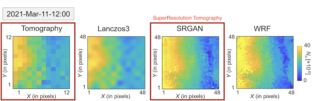
Researchers from IGiG UPWr lead the first high-resolution (HR) GNSS troposphere tomography, leveraging WRF outputs and a Super-Resolution GAN (SRGAN). The approach was evaluated over Poland and California, representing diverse geographic and meteorological regimes.
Key findings:
- SRGAN substantially improves tomographic fields: RMSE reductions up to 62% (Poland) and 52% (California) versus original tomography, outperforming Lanczos3, the starting resolution (input) was 50 km, output resolution was 4 km (10 times)
- Explainable AI highlights hot-spot regions, including western Poland and the lee side of the Transverse Ranges in California.
- Validation used radiosondes and rainy-epoch detection from GPM IMERG.
S. Haji-Aghajany, S. Izanlou, M. Tasan, W. Rohm, M. Kryza, High-resolution GNSS troposphere tomography through explainable deep learning-based downscaling framework, Satellite Navigation 6, 22 (2025), open access, DOI: 10.1186/s43020-025-00177-6. (Published: 14 Aug 2025).
Paper was also featured on NVIDIA Author blog, demonstrating use of AI in weather related research. NVIDIA
 back
back |
 |
 |
 |
Contact
|
INSTITUTE OF GEODESY AND GEOINFORMATICS
Wroclaw University of Environmental and Life Sciences Grunwaldzka 53 50-357 Wroclaw NIP: 896-000-53-54, REGON: 00000 18 67 Phone +48 71 3205617 Fax +48 71 3205617 e-mail: igig@upwr.edu.pl |